Bonaire Salt Flats Guide 2026 — Best Stops, Routes & Photo Tips
The southern coast of Bonaire looks unlike anywhere else in the Caribbean. Bright white salt pyramids rise from flat desert terrain, shallow salt ponds reflect pink and orange depending on the light and the historical slave huts sit at the water's edge as a reminder of the brutal labor that built the salt industry. Most visitors drive past on the way to Sorobon Beach or the lighthouse — the ones who stop and spend time here come away with some of the best photographs of their trip.
This guide covers where to stop, what you are actually looking at, how to time your visit and how to do it respectfully.
What you are looking at
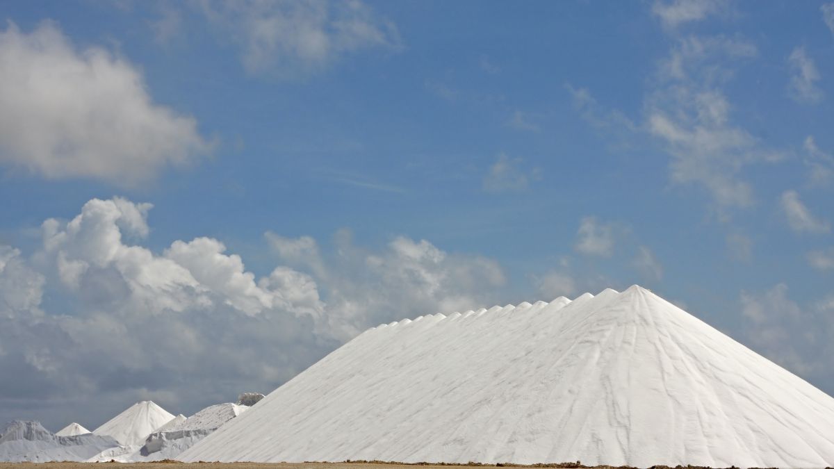
Bonaire has been producing salt commercially since the 1600s. The salt works on the southern coast — operated today by Cargill — extract salt from the sea using a system of shallow evaporation ponds called salinas. As the water evaporates, salt concentration increases, which causes the water to turn progressively pinker due to the pigment produced by salt-tolerant algae and brine shrimp. The bright white mountains are harvested salt waiting for export.
The colored obelisks along the coast — red, white, blue and orange — were navigation markers used by sailing ships to identify which harbor to use for loading. They date from the 1800s.
The small white slave huts near White Pan are among the most historically significant sites on the island. Enslaved workers who harvested salt were forced to live in these tiny structures during the working week — too far to walk back to Kralendijk each evening. They returned to their families in Rincon only on weekends. The huts are preserved and accessible to visitors.
The southern driving route
Most visitors do the salt flats as part of a self-drive south loop from Kralendijk. The route is straightforward — follow the main coastal road south past the salt works. Key stops in order from north to south:
Salt Pier area
The pier is an active industrial loading facility — do not enter restricted zones. The viewpoint from the road gives a clear view of the salt pyramids and the pier structure. This is also a well known dive and snorkel site when no ship is docked.
Pink salt ponds
Several roadside pull-offs give views of the shallow evaporation ponds. The color is most intense in late morning and afternoon when the sun is high enough to illuminate the water but not directly overhead creating glare. Early morning light is softer and better for photography.
Colored obelisks
Four obelisks — one red and white, one blue and white — mark the original landing points. Worth a brief stop for context and photographs.
White Slave Huts at White Pan
The most historically important stop on the southern route. The huts are tiny — barely large enough to lie down in. Standing next to them makes the history tangible in a way that no description fully captures. Treat the site with respect.
Willemstoren Lighthouse
The southern tip of the island. The oldest lighthouse in the Netherlands Antilles, built in 1838. Good viewpoint over the coastline.
Sorobon Beach
The sheltered east coast beach at Lac Bay — calm turquoise water, the main kitesurfing area on the island and a good place to end the south loop with a swim.
Photography tips
Best light
Early morning (7–9am) for soft golden light on the salt pyramids. Late afternoon (4–6pm) for warm light and longer shadows. Midday sun creates harsh glare on the white salt surfaces and washes out the pink pond color.
Polarizing filter
If you shoot with a camera that accepts filters, a circular polarizing filter reduces glare from the salt surface and intensifies the color of the water. On a phone, use exposure compensation to avoid overexposing the bright white salt.
Composition
The contrast between white salt, pink water and blue sky is the shot. Get low if possible — a lower angle makes the pyramids look more dramatic against the sky.
Slave huts
Photograph them with respect. Wide shots showing the huts in the context of the salt works landscape convey the scale of the site better than close-ups.
Important rules
The salt works are an active industrial facility. Several areas are fenced and clearly marked as restricted — do not enter. Do not climb the salt pyramids. Do not walk into the salinas. Stick to designated roadside viewpoints and marked areas. Rangers and Cargill staff are present and restrictions are enforced.
The slave huts are a protected heritage site. Do not touch or damage them.
Recommended tours for the Bonaire salt flats
Prefer not to self-drive the full south loop? These guided options cover Salt Pier, salt ponds, heritage stops, and Sorobon Beach with transport included — pick the format that matches how much island context you want.

Small-Group Guided North & South Tour of Bonaire with Pick Up
Supplied by Bonaire Tours Center
From $65.00 per person
Full island loop with a longtime resident guide — hotel, pier and airport pickup included. The route covers the main island highlights in both directions with a dedicated stop at Salt Pier for the pink water and white salt pyramids. Small group format with morning, noon and afternoon departure options. Air-conditioned vehicle with working seatbelts throughout.
Highlights
- Hotel, pier, and airport pickup and drop-off included.
- Small-group format with many viewpoints and pass-by commentary.
- Morning, noon, and afternoon departure options.
- Optional private tour upgrade for a more personalized experience.
- Dedicated stop at Salt Pier for pink water and white salt pyramids.
What's included
Guided tour by a longtime Bonaire resident • Air-conditioned vehicle with working seatbelts • Round-trip transportation from ship or hotel • Transportation by small van, car, or pickup depending on group size
What to expect: Broad island overview with multiple viewpoints and short photo stops, including approximately 10 minutes at Salt Pier. Good option if you want the full island context rather than just the southern route. Cruise guests meet near the port before departure.

Bonaire Landscapes and Historical Shared Guided Tour
Supplied by Bon Siman The Best Day In
From $50.00 per person
South-focused tour combining the natural and historical landscape of the salt works area. Covers the Pink Salt Pans, Salt Mountains, Slave Huts and colored obelisks with historical context from the guide. Finishes with swimming time at Sorobon Beach on Lac Bay. Bottled water included.
Highlights
- Pink Salt Pans, Salt Mountains, Slave Huts, and colored obelisks with guide context.
- Historical commentary on Bonaire salt labor and coastal landmarks.
- Swimming time at Sorobon Beach on Lac Bay.
- Bottled water included.
What's included
Bottled water
What to expect: Approximately 15 minutes at the Slave Huts at White Pan, 10 minutes at Willemstoren Lighthouse, and 20 minutes at Sorobon Beach. Good value for a guided south loop with historical focus. Timing can vary slightly by group and conditions.

Discover and Explore the Salt Works and Slave Huts in Bonaire
Supplied by bonaire-taxi.com
No reviews yet
From $70.00 per person
Focused specifically on the salt works history and the slave huts — the most historically detailed option of the three. Driver-guide covers the full story of salt production and the slave labor system that operated here. Stops at the salt works and the White Slave Huts. Air-conditioned vehicle throughout.
Highlights
- Deep dive into salt production history and the slave labor system.
- Salt works scenery plus the White Slave Huts at White Pan.
- Air-conditioned vehicle for the full route.
What's included
Air-conditioned vehicle
What to expect: Approximately 30 minutes at Salt Pier for saltworks commentary and scenery, approximately 20 minutes at the Slave Huts at White Pan. Best option if the historical aspect is your primary interest. Exact timing can vary slightly by traffic and conditions.
FAQ
Where are the Bonaire salt flats?
On the southern coast of Bonaire south of Kralendijk along the main coastal road. Most stops are easily visible from the road and require no hiking.
Can you walk on the salt flats?
No — the salt works are an active industrial facility. Many areas are fenced and restricted. Stay at designated roadside viewpoints and do not cross barriers or climb the salt pyramids.
When is the best time to visit for photography?
Early morning between 7–9am or late afternoon between 4–6pm. Midday creates harsh glare on the white salt and washes out the pink pond color.
How long should I plan for the salt flats?
Viewpoints only — 1 to 2 hours. Full south loop including slave huts, lighthouse and Sorobon Beach — 3 to 4 hours.
Is a car necessary to visit the salt flats?
You need transport. A rental car gives the most flexibility to stop when and where you want. The guided tours on this page include pickup and transportation if you prefer not to drive.
Is there an entrance fee?
Roadside viewpoints are publicly accessible. The guided tours above include any applicable fees in their pricing.
What is the historical significance of the slave huts?
The white slave huts near White Pan housed enslaved workers who harvested salt during the Dutch colonial period. Workers were brought from Rincon — the main settlement in the north — and housed in these tiny structures during the working week because the distance was too far to walk daily. They are a protected heritage site and among the most important historical landmarks on the island.
More Bonaire guides
Continue planning your Bonaire trip with destination-specific guides on insurance, comparisons, packing, and practical travel essentials.
Travel Insurance for Bonaire 2026
Medical, evacuation, and activity coverage explained for Bonaire travelers.
Read full guide
Bonaire packing guide 2026
What to bring for shore diving, snorkeling, dry heat, and island driving days.
Read full guide
Aruba vs Bonaire — full comparison
Compare beaches, diving, nightlife, costs, and traveler fit side by side.
Read full guide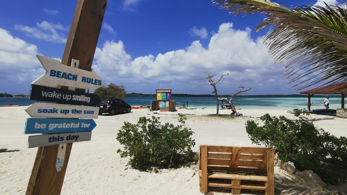
Is Bonaire safe for travelers?
Safety context, practical precautions, and what risks matter most.
Read full guide
Best things to do in Bonaire
Top activities from shore dives and Klein Bonaire to nature day trips.
Read full guide
Where to stay in Bonaire
Dive-focused stays, boutique options, and area-by-area recommendations.
Read full guideAll Aruba Travel Guides
Explore our complete collection of expert travel guides to help you plan the perfect Aruba vacation.
Must Haves
- →Aruba Must Haves — Packing, Gear, Rentals & Insurance Hub
- →Best Reef Safe Sunscreen for Aruba 2026 — Mineral SPF & Aruba Aloe After-Sun
- →Aruba Aloe Products: After-Sun Care, Where to Buy & Store Locations 2026
- →Best Underwater Camera for Aruba 2026 — GoPro, Phone Housings & Snorkel Picks
- →Best Snorkel Gear for Aruba 2026 — Mask Fit, Fins, Dry-Top Snorkels & What to Rent
- →Best Water Shoes & Footwear for Aruba — Rocky Shores, Sandals & Travel Fins
Activities
- →Best Sunset Cruises in Aruba: Luxury Catamaran Experiences
- →Flamingo Beach Aruba & Flamingo Island: Day Pass, Tickets & Where to See Flamingos
- →Best ATV & UTV Tours in Aruba 2026 | Side-by-Side, Dune Buggy, Quad & Jeep
- →Aruba Family Activities | Things to Do in Aruba with Kids & Best Tours for Families 2026
- →Aruba Deep Sea Fishing Charters | Book Deep Sea Fishing Aruba with Carla
- →Best Half-Day, Full-Day & Night Tours in Aruba: Complete Guide
- →Top Private Tours in Aruba: Exclusive Experiences & Personalized Adventures
- →Best Snorkeling Spots in Aruba: Complete Guide to Underwater Adventures
- →Best Snorkeling in Bonaire (2026): Top Spots, Access Tips & Safety
- →Washington Slagbaai National Park Bonaire 2026 — Trails, Wildlife & Tour Guide
- →Caves in Bonaire 2026 — Cave Tours, What to Expect & How to Choose
- →Bonaire Boat Tours & Sailing 2026 — Snorkel Cruises, Klein Bonaire & What to Expect
- →Bonaire Adventure Tours 2026 — Kitesurfing, Landsailing & UTV South Coast
Packing Guide
Rentals
Travel Tips
- →Aruba ED Card 2026: Cost ($20), Official Site edcardaruba.aw & How to Apply — Don't Get Scammed
- →Aruba Airport VIP Arrival & Departure Service (2026): Skip Lines, Save Time
- →Aruba Travel Insurance (2026): From $2/Day, Hospitals & Visitor Guide
- →Bonaire Travel Insurance (2026): From $2/Day, Diving & Hospital Guide
- →Is Bonaire Safe in 2026? What Travelers Should Know
- →Is Bonaire Expensive? 2026 Cost Guide — Daily Budgets, Dining & What to Expect
- →Bonaire Weather & Best Time to Visit 2026 — Month by Month Guide
- →Best Time to Visit Aruba (2026): Month-by-Month Weather, Events & Travel Tips
- →Hurricanes in Aruba: Is Aruba Safe from Hurricanes? Complete Weather Safety Guide
Travel Guide
Dining & Restaurants
- →Best Restaurants in Aruba (2026): Where to Eat by Area, Budget & Vibe
- →Best Local Restaurants in Aruba (2026): Authentic Caribbean & Aruban Food
- →Best Beachfront & Sunset Restaurants in Aruba (2026): Romantic Beach Dining
- →Best Seafood Restaurants in Aruba (2026): Fresh Fish, Lobster & Dock Dining
- →Best Steakhouse & Steak Restaurants in Aruba (2026): Prime Cuts, Parrilla & Marina Dining
- →Best Italian Restaurants in Aruba (2026): Palm Beach Pasta, Lighthouse Views & Downtown Trattorias
- →Best Mexican Restaurants in Aruba (2026): Tacos, Tequila Bars & Cantina Nights
- →Best Breakfast in Aruba (2026): Dutch Pancakes, Resort Buffets & Beach Brunch
- →Best Budget Restaurants in Aruba (2026): Cheap Eats Palm Beach to Savaneta
- →Best Sunday Brunch in Aruba (2026): Buffets, Beach Bars & Tapas
- →Best Family Restaurants in Aruba (2026): Kid-Friendly Places to Eat
- →Best Fine Dining Restaurants in Aruba (2026)